2022 Beach Renourishment Project
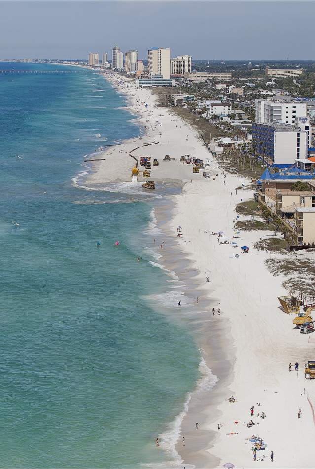
*Image above from 2017 Renourishment Project
2021-2022 Panama City Beach Renourishment Project
The fifth renourishment of the Panama City Beaches was completed April 16th. Shell remediation (resifting of the placed sand where screening methods were not fully in place during construction) is expected to continue on the west end and be complete by approximately May 8th.
This was a very important project for maintaining the health of our beaches! The following questions and answers provide many of the details of the now completed project.
Frequently Asked Questions
Where is this project taking place?
This renourishment project is taking place along two large project beach segments totaling approximately 12 miles. The “western” project area extends from Pinnacle Port to the City Pier. The “eastern” project area extends from St. Andrews State Park (not including the park) to Ocean Towers. The middle of the beach – from the City Pier to Ocean Towers – will not be renourished with this project. This reach of shoreline did not experience enough erosion to justify construction in this area due to authorization and constructability issues. Note that while not directly receiving sand placement, the middle reach will benefit from the sand placement occurring to the west and east.
How much sand is being placed as part of this project? How does this compare to the 1998-1999, 2005-2006, 2011, and 2017 projects?
Approximately 2.1 million cubic yards of sand will be placed with this project. This will be the third largest construction event for the project.
The initial restoration of the Panama City Beaches in 1998-1999 placed approximately 9.8 million cubic yards of sand along the 18.5 miles of beaches. The 2005-2006 project placed approximately 3.3 million cubic yards of sand along 17.5 miles of beaches, and it was conducted in response to 2004’s Hurricane Ivan. The 2011 project placed approximately 1.3 million cubic yards of sand along a total of 7.5 miles of the beaches (east and west ends) and was referred to as a “repair” project as it was conducted in response to several storms following Hurricane Ivan. That project also formally incorporated a project at Pinnacle Port and Carillon Beach. The 2017 project placed approximately 840,000 cy of sand along a total of four project areas which included a half-mile at Pinnacle Port/Carillon Beach, a one-mile segment stretching west from the City Pier, a one-mile segment stretching west from the County Pier, and a one-mile segment stretching from the western end of St. Andrews State Park to Gulf Drive/Hurt Street.
How much is this project costing? And who is paying for it?
The construction cost for the repair project is $28.5 million and is entirely federally-funded; there are no local or state matching dollars required. Because this is an authorized and previously built federal shore protection project, the project team secured Federal Flood Control and Coastal Emergencies funds for this project to replace the sand losses due to hurricanes Michael and Sally in 2018 and 2020, respectively.
How long will this project take to construct?
The project is expected to take approximately 4 to 5 months; however construction may move faster or slower. There may also be circumstances that cause lengthy delays due to construction shutdown, like weather conditions or major repairs to equipment, so please keep checking the Construction Schedule.
What is the project construction schedule?
The project is expected to be under construction beginning September 2021, with an anticipated completion by early 2022. Please monitor the Construction Schedule for further details on schedule as it becomes available. This Construction Schedule will be updated at least every seven days once construction commences.
Who is managing this project?
Because this is a federally-funded project, the U.S. Army Corps of Engineers is managing the construction of the project. The Bay County TDC, on behalf of Bay County, serves as the local sponsor for the project and stays in constant communication and coordination with the U.S. Army Corps of Engineers.
Who is the dredging contractor and what dredge is on site?
Great Lakes Dredge & Dock Co. LLC is the dredging contractor. They also constructed the 2011 beach nourishment project, which was managed and partially federally funded by the US Army Corps of Engineers. The Liberty Island dredge is working on the west end project area, and the Terrapin Island dredge is working on the east end project area.
Where is the sand coming from that is being placed on the beach?
The sand for large-scale beach nourishment projects comes from our permitted, offshore “borrow areas.” The main borrow area is located approximately 1.5 miles offshore of Shell Island, and secondary borrow areas are located near the St. Andrews Bay entrance channel.
How does the sand get to the beach?
The sand is dredged from the offshore borrow areas into a hopper dredge. The hopper dredge motors from the borrow area closer to the project site and hooks up to a submerged pipeline. The submerged pipeline runs from just off the beach up onto the beach and connects to shore pipeline, which runs laterally along the dry beach. The sand is discharged as a water and sand slurry mixture through the pipeline. The sand stays on the beach, and the water runs back into the Gulf of Mexico. Bulldozers reshape the newly discharged sand to meet the designed construction template.
Why are the shells being screened out and where are the dump trucks taking them?
The shell content in the offshore borrow area sand exceeds the permitted threshold. As a result, the shell is being screened out before it is spread onto the beach. The trucks are hauling the sand to a Bay County site for future public-project reuse.
How fast does the project move down the beach? How long will it be in front of my property?
Construction should progress at a rate of 500 feet to 1,500 feet per day. Barring any temporary work stoppages, this means the active construction area may only be in front of your property for a couple days. Please be patient. Everyone, including the U.S. Army Corps of Engineers, the contractor, engineers, and the Bay County TDC wants the project to continue moving down the beach and closer to completion.
How do I access the beach when construction is occurring in front of my property? How do I get over the dredge pipe?
The active work/construction area is limited to an approximate 1,000-2,000-foot section of beach. Walk laterally along the beach until you get around the active work area, locate a sand bridge that goes over the dredge pipe, and you will be able to access the Gulf. The contractor will build these sand bridges over the dredge pipe, which is laid laterally along the shoreline, so that pedestrians may have access to the Gulf.
What are the work hours for construction?
Unless the work temporarily ceases for repair or weather, work will continue 24 hours a day. These are extremely expensive projects, and it is not feasible to halt work overnight or on weekends.
Why is this project important?
The beaches of Panama City Beach that you see today are the result of four previous nourishment projects – one completed in 1998/1999, the second in 2005/2006, the third in 2011, and the fourth most recently in 2017. Hurricane Opal (1995) caused significant erosion of the beaches and left very little dry beach along much of the Panama City Beaches. To combat this erosion, as well as erosion from storms since then, renourishment projects have been constructed. These projects not only provide recreational beach width for the benefit of residents and visitors, but during storm events, the sand also provides critical protection for public and private structures and infrastructure landward of the beach. Because of the 1998/1999 project, there was very little damage to upland development when Hurricane Ivan struck in 2004. The same was true when Hurricane Michael struck in 2018. In addition, a healthy beach provides nesting areas for species such as sea turtles and shorebirds.
This beach nourishment management program is much like a roadway or other such infrastructure – once it is built, it must be maintained. The work you see ongoing now is a small maintenance project that will help ensure continued use of a sandy beach and storm protection for the upland.
What about sea turtle nesting?
The sea turtle nesting season will be wrapping up when the project is expected to begin. There are permitted procedures in place for relocation of nests that may be laid late in the season that would be impacted by the start of construction in September/October.

